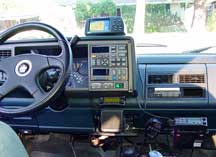
Here's the SP on the dash of my Suburban

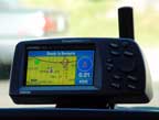
I have a Garmin StreetPilot Colormap on the dashboard of my truck, and a Garmin GPS III+ for non-truck applications.
In the StreetPilot I've loaded the MapSource section for the Bay Area. With this data loaded, the SP tells the the name of every street I drive by. The odd thing about that is that I've driven by certain street for years without knowing their names...until now.
Loading the MapSource data looked like it might be tricky for a couple of reasons. One, the MapSource loader only runs on Windows, and two, the GPS units have serial ports and my computers don't. It was a point of principle to me to use my iBook to accomplish this task.
It turned out to by pretty easy to do. My iBook running Mac OS 9.0.4 runs Connectix Virtual PC 3.0 like a champ. VPC hosts Microsoft Windows 98. I installed the MapSource program into Win98 with no problem. All I needed was a serial to USB connector. Keyspan makes a USB "PDA Adapter" which has a PC-style DB15 connector which accepts the StreetPilot's serial cable DB15. The only thing to remember in the whole setup is to let the Mac handle the serial-to-USB mapping for VPC. In other words, don't try to install any USB drivers into Win98. Just let it think the world is entirely serial and it'll be happy.
I get a real kick out of using my GPS unit (the III+) on commercial airplane flights. Apart from anything else, it gives me something to do. And instead of wondering where we are, or what town that is down there, I know. Very gratifying. It's also interesting, especially on long-haul flights, to download the track log to plot the course on a map.
Even though a GPS unit is a receiver only, it is an electronic device and, as such, subject to airlines' prohibition from operating such devices below 10,000 feet. I also think it's a good idea to request the captain's permission to operate the unit, just in case. I've never gotten refused.
To operate on board a plane, it really helps to have a window seat, or at least be on good terms with the person sitting in the window seat. I use a Garmin GA-27 external attenna which I tape to the bottom of the window using masking tape. This setup has always produced great satellite reception. On long flights, make sure you've got fresh batteries, or carry an extra set. I also prep for the flight by entering the itinerary as a route into the III+, which enables me to track time and distance to destination (are we there yet?).
For both real-time and post-flight track log mapping I use Karen Nakamura's GPSy. The GPSy website is also one of the most informative GPS and mapping resources going. The USB-to-serial setup is the same as with VPC. I've used GPSy in-flight to track the flight's progress, but there's not really any more information presented than is on the receiver's screen and it just wastes the iBook's battery.
The following two pictures are two views of the same track of part of a recent flight I took from San Francisco to London, via Minneapolis and Detroit. The first picture is the track drawn over GPSy's built-in world map, which is correctly calibrated.
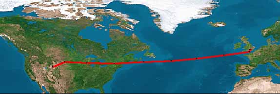
The next picture, below, is the same track drawn on a map generated at Online Map Creation. The map is not a linear projection, and thus there is a significant error in the map's correlation. I point this out because one of the most frustrating things about using GPSy and other GPS programs is finding or creating good quality, yet small, maps to project tracks or locations on. I find that to be true an a global level, like with these maps, and at a neighborhood level.
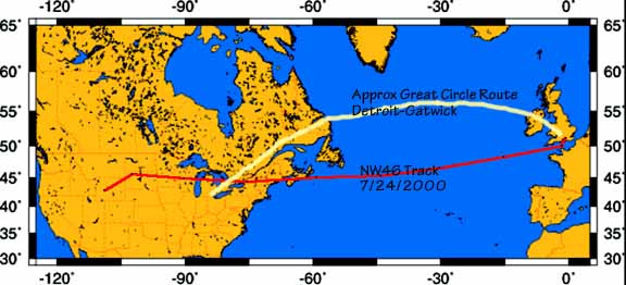
The route passes through Minneapolis and Detroit. The interesting part (for me, anyway) is to note that the route of Northwest 46 from Detroit to London Gatwick on July 24, 2000 takes a very southerly track across the Atlantic. The great circle route would have taken NW46 more or less up the St Lawrence River and thereafter on (what would appear on the map to be) an arc making landfall over northwestern Ireland, and then over Wales, approaching Gatwick from the northwest. Instead, NW 46 actually made first landfall over Brittany and then headed north across the English Channel and approached Gatwick from the south.
I guess it tells you something about me that I find that sort of thing fascinating!